


Imagery in Agriculture
Imagery in Agriculture
March 9th, 2022: Seeing is believing in Ag

March 9th - 4th Edition of my Imagery in Ag weekly series
Visit my website www.easyobservations.com for more info about how we can work together.

Opening thoughts for the week
It’s hard for me not to bring it up because there are so many repercussions, so I wanted to talk about a little how imagery in Ag is going to be incredibly critical in the next few months when it comes to monitoring the worlds food supply. As many have heard I’m sure, Ukraine is the breadbasket of Europe to a large extent. It doesn’t provide everything to everyone, but is very critical to the markets and long term supply of grains and oils in the region.
Now, imagery is constantly used to monitor the worlds food supply and much more. It is literally a huge reason USGS Landsat and the ESA Copernicus programs were commissioned as well as many others. The thing about the war in Ukraine though is it’ll change the entire dynamic of what is grown where not only this year but in years to come.
From what I’ve so far gathered (trust me it’s far from perfect) is that the chance of Ukrainian farmers getting their traditional crops in is poor at best. Winter Wheat is already in from last fall, but still needs to be sprayed, fertilized, and harvested. Most all other crops have yet to be planted even. Logistical and supply issues will be mostly non-existent and even if a crop could get in getting it out of the country is another hurdle. Also, considering Ag uses a lot of diesel I’ve heard Russian forces are taking it to replenish their own needs. Combine all of this with the men (and usually the farm workers) that are trying to defend the country overall and is easy to see it doesn’t look good.
Why imagery has and will continue become more important regarding this is one, countries around the world will want to start tracking where other Ag countries will pick up Ukraines slack. Russia clearly isn’t a contender even though they grow much of the same stuff. Other countries like the US and Canada can add some relief as well as Australia and other parts of Western Europe, but at least in North America drought happened last year in the Northern Plains and Canada regions that produce the most similar crops to Ukraine. This is causing some worry, but it’s too early to tell if that’ll impact anything. Also grain market prices are going through the roof so all these staple crops are trying to compete for what gets grown and where.
Now the other big use of imagery in this current wartime use case is tracking the production of what is grown once it was actually seeded and how much is growing. Everyone will want to know where are the areas that are doing below or above average so they can choose faster where to import grain ahead of other countries to supplement their shortages based on the war. It’ll be a battle for some and get expensive quick if the right actions are not taken ahead of time. This in my mind is going to be huge this year and will really build up the need for many analytics groups in Ag and beyond to do some heavy lifting. I’ll be honest though, figuring out all this stuff isn’t an exact science and there are so many variables. Not all imagery and/or analytics groups in Ag and beyond are even capable of putting this type of stuff together in the time needed. While I’d like to highlight a few experts this week I’m going to need some more time and will shoot for next or the week beyond.
All in all, this whole war in Ukraine I feel is going to shift the entire dynamic on how large scale macro analytics are used with imagery in Agriculture and especially with government processes around the world. Imagery groups in Ag and EO groups targeting Ag have been waiting for a moment like this for a long time, though not wanting it this way of course. You see EO has been dominated by the Defense Agencies for decades if not entirely from their beginning. Basically 95% or more of all the money in EO comes from governments, but especially Defense. Now with Food, Ag monitoring, and beyond combined with the other fun stuff on Sustainability, Carbon, and Environmental there is a shift I see coming in government money also going into Agriculture much like Defense. There is and can be very common connection points between war/defense and Ag production. The Arab Spring comes to mind.
There are many smarter people than myself working on these issues I can say and it'll be dealt with likely through many different avenues. The biggest thing though is the attention imagery is getting now via Defense actions (viewing troops and vehicles) and where it will transition monitoring crops and changes to the landscape of where crops are grown.
I’ve been a proponent of trying to help groups figure out and understand just how important these things are and how imagery can help for awhile now, but there is always something in the way. Technology, money, legal, processing, interpretation, and much more to name a few. Mainly, groups just give up after some amount of time because of these issues and while some governments do use imagery for these needs, they usually don’t do it well and are very limited financially on what they actually need. I personally think this war is about to change all of that, but I’m not sure exactly when. It could be sooner than later or could be later due to how the season and other countries shore up their crop growing resources to combat the likely shortages. In any realm, I’m keeping a keene eye on it and will do my best to showcase what I find as time goes on during this unfortunate and unnecessary war conflict.

Highlight of the Week
As I mentioned in my post last week, I plan to cover a main player in the Earth Observation world each week that is working in Agriculture until I can’t find any. I’ll be honest though, I might throw a wrench in this too somewhat as there are many analytical groups also that could warrant some attention that have more of a realistic product compared to just EO satellite startups. For this week it won’t matter as the group I’m covering has both fortunately for them.
This week I’m going to highlight Earth Daily Analytics. The basics to them are they deal heavily with Ag based imagery and data analytics now, and in 2023 plan to rocket up 10 of their own satellites to further enhance theirs and others Agriculture solutions. Here is more on the three main product segments they support now and will in the future.
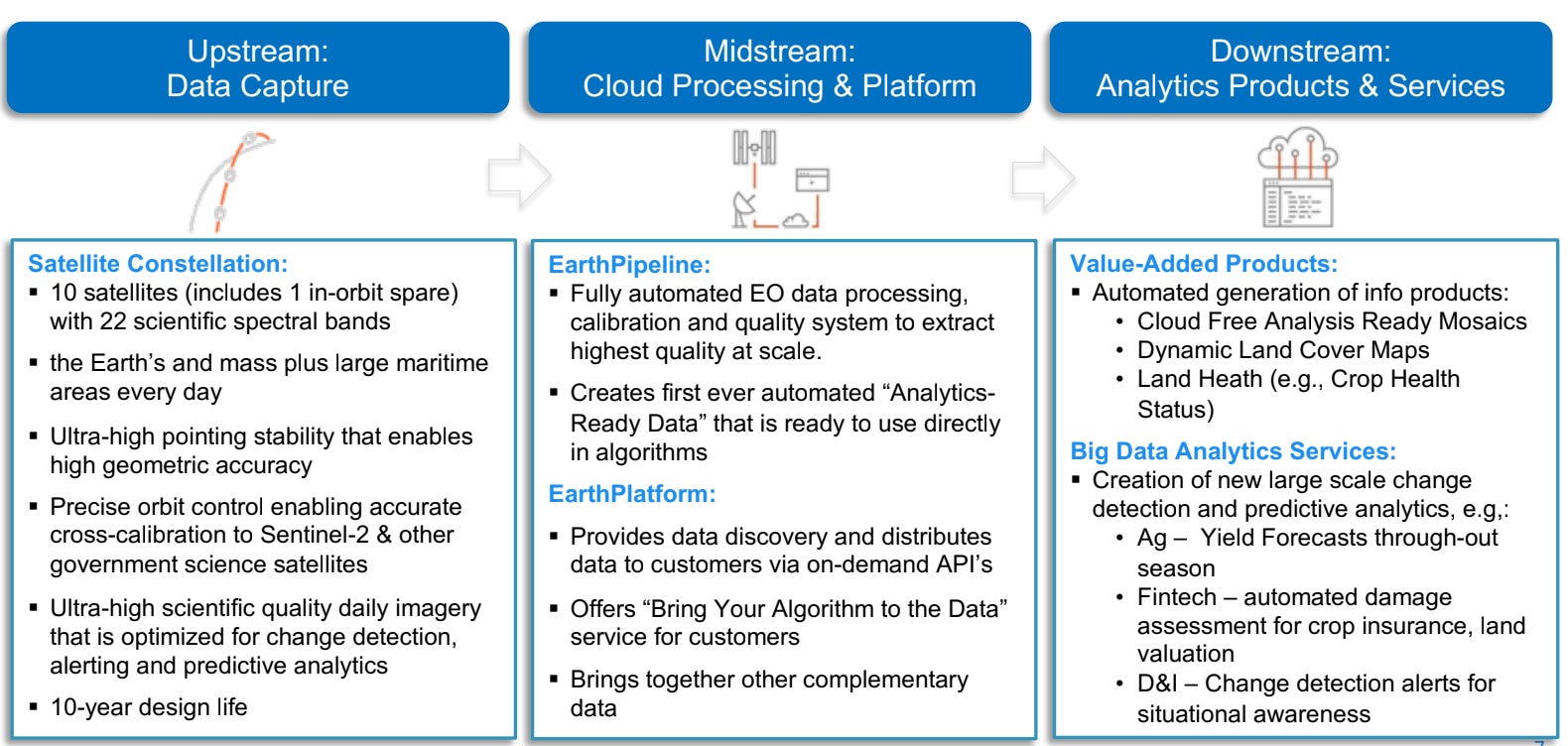
What is their story? - So I can start with a fun fact with this group. While they’ll hate to admit it, they are the result of a previous endeavor called Urethcast. It went bankrupt a few years ago and actually had two satellites called Deimos 1 and 2 (Under GEOSAT brand through another company), which was a high resolution satellite. The analytics side actually came from Geosys (the oldest Ag based imagery analytic group in the world and my family’s company old rivals...it’s all good now) which they purchased from Land’O Lakes in 2018. There is way more to this whole story and now is not the time, but regardless they have history and a lot of it. They have been in Ag forever, have actually managed and started to build satellites beforehand, and have clients in Ag. Compared to others in the EO/AG market, they’ve done stuff and a decent amount. They’ve been in it and learned what to do and not to do especially around building and managing satellites. They are based in Canada and are backed by Antartica Capital. They have many core employees that are veterans to both sides of the industry. Overall, they are compelling, so let’s go deeper.
Why they are different? - From what I’ve learned their new satellites will have a technical and scientific match to Sentinel 2a and 2b. This is huge and is a rare quality I know others do not have yet. Adding daily availability at that quality with more resolution is big. I compare it somewhat to the old RapidEye sats that Planet recently decommissioned. Having this will help cross calibration of future and also past data so modeling with their new data can take place almost immediately within other models already created for Sentinel from the past. This saves analytical companies, including EarthDaily themselves a huge time and cost advantage in not having to rebuild or change their models much if even at all.
With the common plus additional spectral bands (shown below) in what they call “super-spectral” it provides some unique and powerful abilities that haven’t not been available before. Especially with a daily cadence and top quality to boot.
VNIR Cameras: 11 spectral bands (Visible to Near InfraRed), 5 meter GSD
SWIR Cameras: 6 spectral bands (Short Wave InfraRed), 95 meter GSD
Thermal Cameras: 5 spectral bands (Medium to Long Wave InfraRed), 150 meter GSD
Swath Width: 240 km

What can they do now? - Basically analytics through their EarthDaily Agro (Geosys) program. This included mainly supporting ESG and crop monitoring, Precision Ag processes, and Macro Ag-Based Analytics like crop type classification, yield prediction and similar solutions. They mainly target Crop Insurance, Ag Lenders, and Commodity Traders as well as large Ag Retailers and your big corporate chem/seed/fertilizer groups. Overall, they are pretty B2B centric and don’t go direct to smaller businesses much or growers at all.
As their General Manager and my long time cohort Dave Gephardt has to say, “For the past dozen or so years, we’ve been trying to drive value into the agriculture value chain using satellite imagery, weather, and other datasets. The biggest challenges we faced over the years are quality, frequency, and coverage needed to support our large customer needs. This is why we started designing the EarthDaily Constellation so many years ago – specifically to address these issues for agriculture.”
What will they do in the future? - All of the above with much much more data in their control more or less. Their focus is going to be on Water, Soil Health, and Automating Analytics. Dave adds, “This unique data and our advanced Geosys Platform will allow us to address some of the world’s greatest challenges and opportunities – more refined and automated analytics for understanding the impact of water, soil health, and production practices on crop health and progress.”

Overall, they should have the best capabilities internally with their sats because well, it’s their data. While they will be selling and distributing out their raw data, they clearly will have the best ability to take advantage of the Ag vertical themselves over others. Something to think about there and a growing trend similar to what others are thinking too in the EO community.
What’s the 411? - To saying simply, they’ll be a pretty powerful group in EO and especially in Ag if, big if, they get the satellites up in space. Now, they are further ahead than most as they have secured enough funding to build and launch them according to this press release. That is a big step and one that some do not have yet. Their Analytic solutions now are prosperous and make decent revenue from what I’ve gathered, but competition is gearing up fast not only with other data sources but other companies building systems to manage EO data. Though, with them having their own source they should be able to remedy competition better than most. Overall all they are a player, plan to play much bigger, have a ton of experience in Ag already, and have many clients in Ag throughout the world. Some could call them a “Planet” killer potentially, but we’ll have to wait on that.
Earth Daily’s biggest challenge is going to be other EO data providers fighting for the same piece of the pie in Ag and also somewhat competing against their own clients they sell data to. Earth Daily is Ag focused and are not alone. Ag also traditionally hasn’t been very keen on spending a ton of money on imagery either beyond a few cases. This could force them to look into other industries too. Will they or can they dive into other verticals? Maybe, but while that is not their main MO selling data to others if they want it likely won’t be an issue.
Overall, I’m sure you’ll be hearing much more from them in the near future and if they get those satellites up it’ll be a pretty big deal in the monitoring of the planet we live on. I wish them the best and am excited to see what they can do.

Quick takes
Hype gone wild and I like it - Field Boundary Detection
So, I thought I’d combine these as I see a lot of hype but also a lot of positives with it.
This has be ongoing for the last few years and there is generally good reasons why. Most of the world beyond the US doesn’t have parceled out field boundaries with some general accuracy. The US does have some called CLUs (Common Land Units), but it older based in 2007 and updated ones can only be had through USDA agencies and even those are still fairly inaccurate. Other countries and their governments do have some as well, but usually don’t allow others access.

Anyway, there is a need. The problem, most will use easy and free Sentinel data to automate a process to draw them via some sort of ML/AI process. While some processes are better than others it is far from perfect. It can be hard to define what is a boundary and what isn’t, especially when similar crops are grown side by side. Also the difference between ditches and grass can become complex as well. Some are using “Super Resolution” processes that downsample Sentinel to make it appear closer to high resolution and in doing so smooths out the pixels enough to see more artifacts in the image. This can help define boundaries better to some affect, but it doesn’t replace actual high res data. While doing this process can be good for general field boundary use as a reference dataset, it isn’t good enough for real acreage delineation and legal needs. We need cheaper high res scalable data to do it right plus the right methods to automate them. It’s coming.
Pretty much all imagery analytic companies are attempting to do this as they need a boundary anyway to sell some of the other products they are trying to push like Crop Type Classification, Yield Prediction, Macro Crop Monitoring, Change Detection, and yada yada yada usually. It becomes part of the process. The issue for me is accuracy in the acreage since if someone uses these boundaries for say Crop Type Classification they usually want the acreage as they’ll use this for potential commodity trading for instance. If the acres are not accurate it can skew things pretty bad. Using Sentinel in doing this can really only give you + or - 5-10% error factor. That amount in my mind is too much to rely on and I’ve heard groups complain about this before.
Now like I mentioned, if using them just for reference they can be okay. It really depends on the use case and making sure the client knows they are not perfect. If someone automated say NDVI for field boundaries it is very possible the results will be skewed towards your actual field especially if the boundary isn’t pretty accurate. Anyway, something to think about in using these type of analytical imagery processes. I do like though how some are approaching it like DigiFarm out of Norway. Also, I’m like 70% Norwegian and their founder’s family grew up like 10 miles from my families there so I’m a fan. You’re welcome Nils.
Closing thoughts for the week
I usually had some other sections and pieces from my last newsletters you may see missing so I’ll be honest, this week got away from me and I just ran out of time. That and I’ve gotten a little feedback that my newsletter is a pretty long read. So, I’m going to cut it down a little if some of the other topics get too long. Anyway as always, I hope you liked this week’s edition and will share it out to others that would likely subscribe to it. Cheers!

Thanks for reading Easy Observations! Subscribe for free to receive new posts and support my work.