

Imagery in Ag
Imagery in Ag
April 18th: Here's a few Imagery Easter Eggs

The 8th Edition of my Imagery in Ag series
Visit my website www.easyobservations.com for more info about how we can work together.
Opening thoughts for the week

Welcome back after my little two week hiatus! I wasn’t necessarily planning this gap and from time to time I may do weekly here and there still, but it’s been a busy few weeks and I’m also pretty sure I have had Covid brain too. I digress.
Anyway, I thought I could open up this addition with something that is naturally a pretty big talking point in Ag when it comes down to what imagery a group wants and what they are willing to pay for. You know, Free vs Paying for data. The age old problem when it comes to data in most things, but especially it’s seem to be prevalent with our cheap stubborn asses in Agriculture. It’s just a reality and when it comes to data, many in Ag are not accustomed to paying for it. They will pay out their rears for machinery, land, inputs, and stuff that is physical, but when it’s something generally intangible like software or data they start to squirm.
So in the spirit of my meme what does this mean for EO in Ag. The thing is there has become this looming issue for many in Ag.
“Do I just use Sentinel and Landsat because it is Free which is generally good enough for showing crop changes and such or do I go for something higher resolution or higher quality to grab the extra edge?”
The answer isn’t simple for anyone and really there isn’t a good exact answer. Many will fight saying you can only use drones, or aerial, or high res satellite or something like that while others will say that they get by fine with Free data. They are both right and you really have to look at the details at what they are trying to achieve.
I’m not going to go into the exact merits of one vs the other as that is for another time. I just wanted to start help showcase the general issue to this fighting and how EO groups, especially satellite startups, are getting cornered into this fight with little weapons to back themselves up against Ag’s stubborn personalities. I plan to go into this more and in different way with each additions or even separate ones.
Highlight of the Week
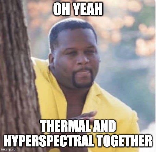
ConstellR: A German based EO startup building Thermal observing based satellites. These guys have had a busy 2022 so far. The launched their first test satellite in February and just this week they acquired a current partner of theirs in ScanWorld, a Belgian company that works with Hyperspectral data and plan to launch their own satellites as well. They started working together last fall actually so I’m guessing through this process they figured why not come together even further. In saying that, this below is what they stated in why they are working together.
“This [partnership] will enable us to deliver an even better service to our customers in agriculture and beyond. In fact, I believe that what we are building here will be a game changer for all ESG related monitoring activities and enable a global quantification of key metrics with unprecedented accuracy, precision, and timeliness.”
What is their story? I’ll sort of have to split this up between Constellr and Scanworld as this is all new being together, but both are fairly new to the Space and Ag world as companies. It looks like they both started around 2020 or slightly before, so yeah new. They clearly though have grabbed professionals from both sides and beyond to create and build their products. Constellr is a little further ahead as they’ve actually built and launched their first test thermal satellite into space, while Scanworld’s plans for their initial launch is in the late 2023 range for their first test hyperspectral satellite.
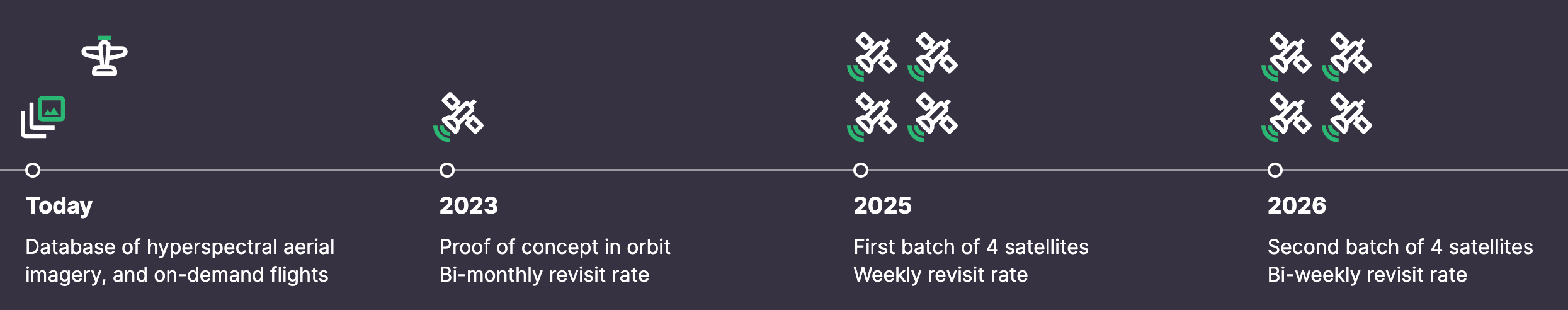
ConstellR still has to put up their main constellation and that won’t be going up till end of 2023 according to their website. In saying that, both together will seem to have a busy 2023 if they can get all their ducks in a row.
Why are they different? The main difference with ConstellR is the fact that they are going after Thermal. There are other thermal sensors and satellites now like Sentinel 3 from the ESA and also Landsat 8 has some sensors on it from the USGS but while free, they are low in resolution like 100m and are not particularly dedicated to any specific vertical. These guys are not alone in trying to build thermal satellites as other like Albedo, Ororatech, SatelliteVu, and Hydrosat are in the mix as well, be it for different purposes and stages.
As for Scanworld, not knowing the full specs of their proposed satellites make it tough to really decipher if they are that different from the seemingly countless new hyperspectral satellites going up. Just look at this graphic below to get a sense who else is building some and I’ve also talked about a few like Satellogic and Wyvern before. In any realm, it’s a busy sector right now.

What can they do now? Now that they have a test satellite up I suppose the simplest answer is they can send you test data. As for ScanWorld, it seems they only can provide Aerial data on a limited scale right now. I’m guessing ConstellR can also get Aerial data if warranted too. Much like other Space startups, both these groups together now or separate before are still in really early stages of their development. While they likely can help illustrate how their tech will be beneficial, large scale product development is not there quite yet. Now there is nothing wrong about that, but just a note to my readers in being patient.
What’s the 411? My main take from this grouping of EO contenders is that they are striving for Ag and if they get their birds up they should garner some good interest. The combination of how the different hyperspectral bands relate to thermal can definitely crack open some new insights into how a crop grows and with their goal, on a massive scale. I’m excited if they get to this point of literally fusing these datasets together. Matched with other Ag related data and even other imagery data it could become quite useful.
Of course in saying that they have a long road ahead of them and will have to raise quite a bit more capital to do so for their full constellations. These newer wins should help ConstellR get their, but time will tell. Also, for all the hype around this new acquisition in ScanWorld my gut feeling is that it happened in part due to financial stress. Using airplanes to get your hyperspectral business off the ground is fine and all, but has a lot of limitations. To add, there are many competitors in that aerial space too. I’m sure it became hard garnering contracts with just that while also trying to support the goal of putting up a satellite also. This has happened before. So while I can’t blame ScanWorld for trying this approach, I feel the pressure caught up to them finally.
In any regard, I think if these two can put their heads together and showcase real results from real satellites in real space then they could have something big being more than JUST a thermal or JUST a hyperspectral space company. I wish them the best of luck.
Quick takes
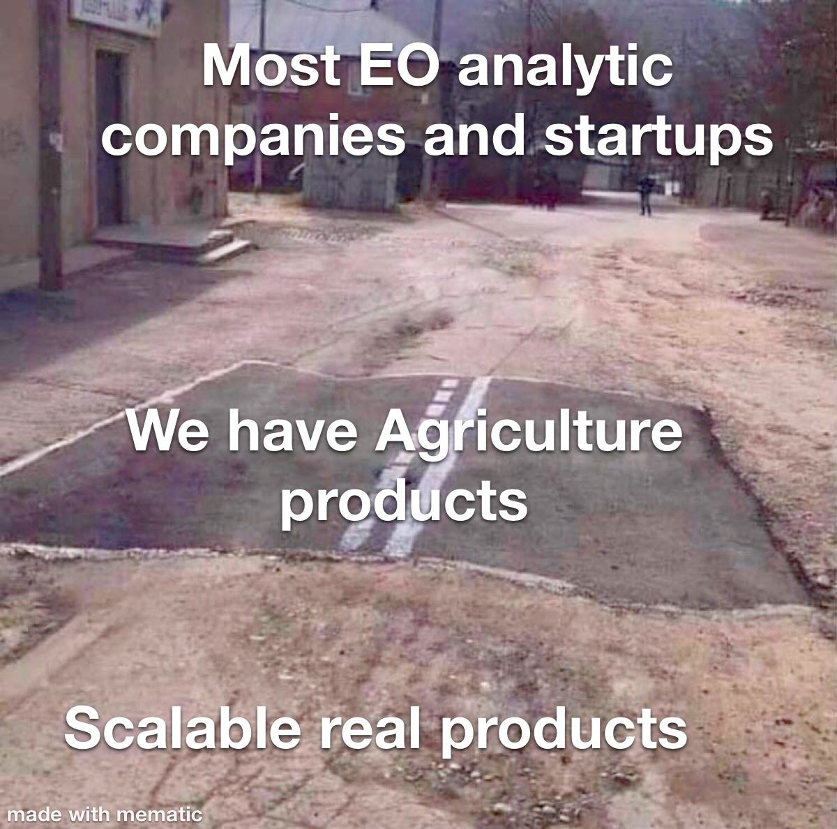
Let’s take a look at the above meme for reference. What you see here is a constant interpretation of what I often see EO groups from all shapes stating . Basically, they have a process or “product” that can solve certain problems in Ag they say. This could be crop health monitoring, change detection, crop type classification, yield prediction or something like that. All in all, it sounds good on paper or through a Power Point, but what most don’t do is look beyond the surface of how they are actually producing the process or product.
What I often see unfortunately is some form of a polished turd per say. Not that some don’t have something valuable or decent, but it’s pretty common for a group to say they can do something because they have some GIS licenses and some Data Scientist or GIS specialists that manually create these products. What they usually don’t have is a real refined scalable dynamic product that say you can subscribe to or that is automated in some fashion. They say they have a product and promote it as this nice shiny new (paved road above) process, but what they really have is a thrown together project (gravel road) based analysis of some manually ingested data that some guys put together in a GIS program they bought off the shelf.
Once again, I’m not saying all do this or even a product like that is always bad. It depends and there are some that have built some really good custom tools and geospatial abilities on top of previous project based products. What I’m saying is that it is really easy for someone with the right off the shelf program and a few good engineers to put together something that “looks” like a refined geospatial product. There isn’t necessarily anything wrong with project based work, but there is a big difference between that and a custom developed software that dynamically uses EO data to create solutions. Some like to sell an Ag group these products as that yet they actually just manually sell project based products. That is what grind my gears at times.
Building something dynamic and scalable is hard in the EO world. It costs a lot of money, takes a lot of time, and takes really highly skilled professionals to do it write. Especially in the Ag space. It also takes highly specific skilled professionals that understand not only the technical process, but also the business process in how a product gets delivered and used by the Ag end client. Being that that is usually a Service Provider like an agronomist or even a grower themselves building something geared for them to use adequately is complex to say the least.
All in all, if you are an EO analytics or data group please refrain from saying you can build generic Ag products when you know you can’t or shouldn’t. The better thing to do is to partner with groups that do have a more refined Ag geospatial products already that are scalable and dynamic and try to work with them to enhance what they might have. It is a way more sustainable process than going solo at it into this Ag industry and selling a bunch of “shiny turd” projects that are sold as “software systems.”
Closing thoughts for the week
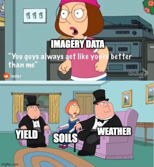
The above meme is insanely true in the Ag world from the research and agronomy side I feel. Now, I’d say imagery is catching up though especially around all the carbon, environmental, and sustainability stuff. I don’t blame people for feeling this either as yield, soil, and weather data seem more tangible and real in Ag as they usually have a very specific designation or number tied to it that is more understandable. Sure imagery does to an extent too, but it takes a lot more interpretation. That is the real issue.
In all reality, all these datasets should be used together if possible to help showcase better end results. That is definitely done at times and it’s maybe why I complained somewhat about project based EO products. Much of the issue is the so-called popular data sets can be harder to come by or even understood when combined with imagery data for a project. I’ve ran into this before with others and sometimes its a privacy issue say with yield data, or the data isn’t good enough via weather or soils.
As an example, if you are not aware of the SURGO soils data in the US I’ll tell you a little secret. They were never planned to be used for agronomic purposes, mainly taxation and valuation. If you use it for agronomic modeling as its open and available, you could have some issues. Many do it though.
What I’m trying to say is EO data while great in many forms has also many limits to other data out there in Ag, be it limited as well in its own right. Many want to create models and sell products or solutions based on those datasets and many have. The reality is that they all individually are not perfect and even though the popular ones have real more understandable numbers to them it doesn’t mean they are much better. It depends like I’ve said and junk data is just junk data, especially if it isn’t cleaned which is a giant issue in Ag. Just think of this before you might start modeling and creating a bunch of new products with these datasets project based or not. The real data you want is much more elusive and hard to find, but I feel will come in due time.
Other Stuff
To add a few more items from the last two weeks:
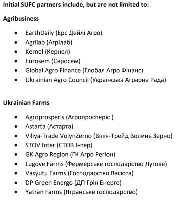
Earth Daily and other partners helping Ukrainian farmers and businesses: This is a pretty cool thing between all these groups and it helps show the power of Earth Observation in the wild. I know some others trying to do semi-similar things as well, but regardless I think most of us have seen how others in the EO and Ag space are starting to add in charity processes as well. Good PR and good deeds, can’t go wrong with that.
Planet with their recent Vandersat acquisition create Planet Variables
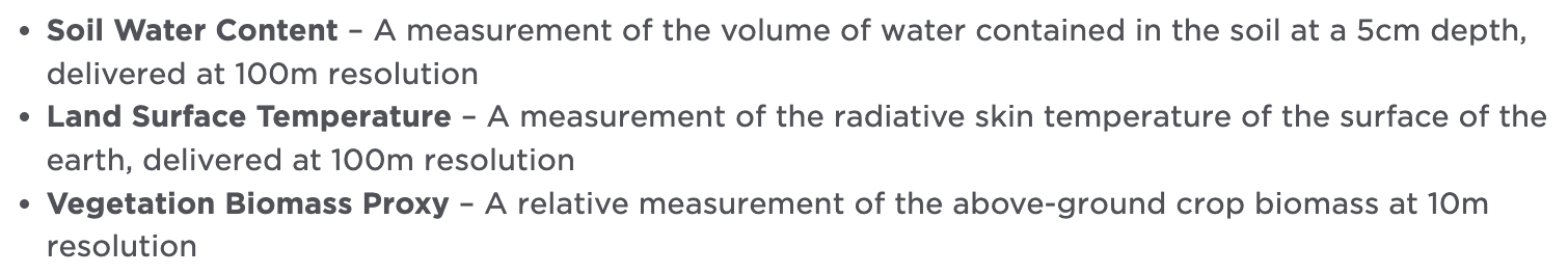
Adding a few thoughts to this, it seems on the surface like some cool data I guess as what they are providing above. I’m not sure on the practical side of it for others beyond answering some curiosity questions overall. I see it as more feel good data to show other businesses a general ability that they now have. Seems fair to me, but the utility for growers and agronomists isn’t quite there with this which likely wasn’t their goal anyway. I’m curious on the cost though.
Thanks for reading Easy Observations! Please Share, Subscribe, and Comment if you are so kind.